JAMB Geography 2020 Past Questions & Answers
40 JAMB Geography 2020 questions with verified answers and worked explanations. Here are the first 25 — sign up free to practise the full paper.
If a map at scale of 1:50,000 is reduced by half, what is the scale of the new map?
- A.1:100,000
- B.1:750,000
- C.1:200,000
- D.1:25,000
When a map is reduced by half, it means the features on the new map are half their original size, which makes the scale smaller. To find the new, smaller scale, you must multiply the denominator of the original scale by 2. Therefore, 50,000 multiplied by 2 gives 100,000, making the new scale 1:100,000.
Common mistake: Students often mistakenly choose 1:25,000 because they divide the denominator by two, forgetting that reducing a map makes the scale smaller and the denominator larger.
Which of the following is not a form of precipitation?
- A.Haze
- B.Snow
- C.Hail
- D.Fog
This question asks to identify the option that is not a form of precipitation. Precipitation is any form of water, liquid or solid, that falls from the atmosphere and reaches the Earth's surface. Snow and Hail are forms of solid precipitation. Fog and Haze are not precipitation; they are water droplets or particles suspended in the air. Given the options, both Haze and Fog are correct answers. However, in many exam contexts, Haze is considered the best answer as it is composed of dry particles (dust, smoke) rather than water droplets like fog, making it fundamentally different from water-based precipitation.
Common mistake: The most common mistake is confusing fog with precipitation; while fog is made of water droplets, it is a form of condensation that remains suspended in the air near the ground and does not fall from clouds.
Which of the following rocks is composed of the skeletons of microscopic sea plants and animals?
- A.Granite
- B.Chalk
- C.Slate
- D.Sandstone
Chalk is a type of limestone, which is a sedimentary rock formed organically. It is specifically made from the accumulation of the tiny calcite skeletons of microscopic marine organisms called coccolithophores. Over millions of years, these remains settled on the ocean floor, compacted, and cemented together to form the soft, white rock known as chalk.
Common mistake: Students might mistakenly choose Sandstone because it is also a common sedimentary rock, but it is formed from cemented sand grains, not the remains of living organisms.
When on looks at a soil profile, the first characteristic to be noticed is soil
- A.Structure
- B.Moisture
- C.Texture
- D.Colour
When you look at a soil profile, which is a vertical cut through the ground, the different layers often have distinct colours that are immediately visible. These colours, such as red, brown, or black, are the most striking and first characteristic you notice before you even touch the soil. While texture and structure are also important, they require closer inspection or feeling the soil to be determined.
Common mistake: Students may incorrectly choose 'Texture' because it is a fundamental soil property, but determining texture requires feeling the soil, whereas colour is the first characteristic observed visually.
Which of the following areas is subjected to frequent earthquakes
- A.South Africa
- B.The Sahara Desert
- C.The Canadian Shield
- D.Northern Australia
The Canadian Shield, although generally a stable region, experiences frequent small earthquakes. This is because the land is slowly rising after the heavy ice sheets from the Ice Age melted thousands of years ago. This process, called post-glacial rebound, causes stress in the Earth's crust, leading to these tremors, unlike the other listed areas which are more stable.
Common mistake: A common mistake is to assume that old, stable landmasses like shields have zero earthquakes, overlooking the minor but frequent tremors caused by processes like post-glacial rebound.
The above diagram on which the contours are in meters shows
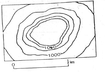
- A.Mesa
- B.Knoll
- C.Drumlin
- D.Volcanic cone
The diagram shows a set of closed contour lines with values increasing towards the center, from 1000m to over 1060m. This pattern on a map represents a hill or an area of high ground. A knoll is defined as a small, low, rounded hill, which perfectly matches the landform depicted by these contour lines.
Common mistake: Students might confuse it with a mesa, but a mesa has a distinct flat top, which would be shown by widely spaced contours at the highest point, unlike the pattern in the diagram.
Which of the following countries has a large number if people if African descent?
- A.Brazil
- B.Spain
- C.Canada
- D.Chile
The question asks about the distribution of a specific population group, which is a core concept in population geography. During the transatlantic slave trade, Brazil received the largest number of enslaved Africans, far more than any other country in the Americas. Consequently, Brazil today has the largest population of people of African descent outside of the African continent.
Common mistake: Students might mistakenly choose Spain because it was a major European power involved in the slave trade, but the vast majority of enslaved Africans were transported to its colonies in the Americas, not to Spain itself.
When it is 12.00 noon on longitude 30°W, local time on longitude 75°E is
- A.7.00 am
- B.7.00 pm
- C.5.00 pm
- D.5.00 am
First, find the total difference in longitude by adding the two values since they are in different hemispheres (West and East): 30° + 75° = 105°. The Earth rotates 15° every hour, so we divide the longitude difference by 15 to find the time difference: 105° ÷ 15° = 7 hours. Because longitude 75°E is to the east of 30°W, its time will be ahead. Therefore, you add the 7 hours to 12.00 noon, which gives you 7.00 pm.
Common mistake: Students often make the mistake of subtracting the time difference instead of adding it, forgetting that locations to the East are always ahead in time, which leads them to incorrectly choose 5.00 am.
Large scale migration of people from one country to another may be explained by all of the following except
- A.Civil war
- B.Drought
- C.Higher standard of living in the host country
- D.Oppressive home government
The question tests your understanding of push and pull factors in migration. Push factors are negative conditions that force people to leave their home country, while pull factors are positive conditions that attract them to a new country. Civil war (A), drought (B), and oppressive government (D) are all push factors. A higher standard of living (C) is a pull factor. Since the question asks for the exception among the given reasons, the pull factor is the odd one out in a list dominated by push factors.
Common mistake: Students may get confused because all four options are valid reasons for migration, but they fail to spot that the question is asking them to identify the pull factor among a list of push factors.
Urban centres originate mainly as a zone of
- A.Tourist attraction
- B.Non-primary economic activity
- C.Greater social intercourse
- D.Transport concentration
Urban centres, such as cities and towns, primarily begin and grow because they are centres for non-primary economic activities. Unlike rural areas that focus on primary activities like farming, urban areas offer jobs in manufacturing, trade, and services. People move to these settlements to find this type of work, which causes the area to become urban.
Common mistake: Students might mistakenly choose 'Transport concentration' because transport routes are vital for cities, but these routes are primarily built to support the main economic activities, which are the fundamental reason for the city's origin.
U and V are two places along the same Meridian on latitude 20°N and 25°N respectively. The shortest distance between the two places is approximately
- A.560km
- B.680km
- C.500km
- D.620km
To find the distance between two places on the same meridian, first find the difference in their latitudes, which is 25° - 20° = 5°. The distance of one degree of latitude on the Earth's surface is approximately 111 km. Therefore, the total distance is the difference in latitude multiplied by 111 km, which gives 5° x 111 km = 555 km. The closest option to this calculated value is 560 km.
Common mistake: Students might mistakenly use 100km as the distance for one degree of latitude, leading them to incorrectly calculate 5° x 100km = 500km (Option C).
Which of the following statistical mapping techniques is most suitable for showing the spatial distribution of cattle in different northern states of Nigeria
- A.Isopleths
- B.Pie chart
- C.Proportional circles
- D.Dot map
A dot map is the most suitable method because it is specifically designed to show the spatial distribution of a feature. Each dot on the map represents a specific quantity (e.g., 1,000 cattle), and their placement shows the exact location and density of the cattle population across the northern states.
Common mistake: Students might mistakenly choose proportional circles because they also show quantity, but dot maps are superior for showing the detailed distribution and density within an area.
The progressive widening of joints and cracks in limestone by solutions, initially lead to the formation of
- A.Cliff and dry valleys
- B.Caves and caverns
- C.Grits and clints
- D.Stalactities and stalagmites
In limestone regions, rainwater acts as a weak acid and dissolves the rock along joints and cracks in a process called carbonation. This process widens the cracks into deep grooves called grikes, leaving behind raised rectangular blocks of limestone known as clints. Therefore, grikes and clints are the initial surface features formed by the widening of joints in limestone.
Common mistake: Students often mistakenly choose 'Caves and caverns' because they are a major limestone feature, but these form underground and later in the process, not initially on the surface.
One of the consequences of global increase in the carbon dioxide content of the atmosphere is
- A.Reduced visibility
- B.Increasing air pressure
- C.Decreasing temperature
- D.The destruction of the ozone layer
An increase in carbon dioxide and other pollutants in the atmosphere leads to major environmental problems on a global scale. These gases contribute to the damage of the protective ozone layer, which shields the Earth from the sun's harmful ultraviolet rays. While carbon dioxide is the main driver of global warming, exam questions often group it with other pollutants that cause atmospheric damage like ozone depletion.
Common mistake: Students often mistakenly choose 'Decreasing temperature' because they forget that carbon dioxide is a greenhouse gas that traps heat, leading to an increase, not a decrease, in global temperatures.
A good overland transportation system promotes economic development because it
- A.Provides employment for drivers
- B.Fosters interregional trade
- C.Reduces fuel consumption
- D.Reduces depreciation of motor vehicles
A good transportation system is crucial for economic development because it connects different places, allowing for the easy movement of goods and people. This connection makes it possible for regions to trade with one another, which is called interregional trade. When regions can trade, they can sell their surplus products and buy what they need, which boosts economic activity and growth for everyone involved.
Common mistake: Students may mistakenly choose option A because providing employment is a positive economic effect, but it is a much smaller and more direct benefit compared to the large-scale impact of fostering trade between entire regions.
A layer of fine wind-deposited sand on silt is known as
- A.Loess
- B.Bajada
- C.Barchan
- D.Seif
The question asks for the name of a landform created by the deposition of fine particles by wind. Loess is the specific geological term for a widespread deposit of fine, yellowish-grey sediment like silt and clay that has been transported by the wind. The other options are incorrect because Barchan and Seif are types of sand dunes, while a Bajada is a landform created by water action.
Common mistake: Students often mistake Loess for other wind-deposited features like Barchan or Seif dunes, forgetting that Loess specifically refers to fine silt deposits rather than larger sand accumulations.
The most dominant pair of active factors affecting plants growth is
- A.Topography and man
- B.Climate and Topography
- C.Soil and fauna
- D.Climate and soil
Climate, which includes rainfall, temperature, and sunlight, provides the energy and water plants need to grow through photosynthesis. Soil provides essential nutrients, water, and a physical anchor for the plant's roots. Together, these two factors are the most critical and active influences on where and how well plants can grow.
Common mistake: Students might choose 'Climate and Topography' because topography is an important factor, but they forget that soil is more directly and actively involved in providing nutrients and support for plant growth.
In what order do the following occur from the surface to the bottom of an oil well?
- A.Gas, water, oil
- B.Gas, oil, water
- C.Oil, water, gas
- D.Oil, gas, water
The correct order is based on the density of the substances in the underground rock trap. Natural gas is the least dense (lightest), so it rises to the very top. Water is the most dense (heaviest), so it sinks to the bottom. Crude oil has a density between that of gas and water, so it forms a layer in the middle. Therefore, an oil well drilled from the surface will pass through gas, then oil, and finally water.
Common mistake: Students often mistakenly choose 'Gas, water, oil', forgetting that oil is less dense than water and therefore floats on top of it in the reservoir.
The process by which materials are physically transferred from one soil layer to another is called?
- A.Eluviation
- B.Illuviation
- C.Leaching
- D.Physical weathering
Leaching is the correct answer because it is the process where soluble materials, like minerals and nutrients, are dissolved in water and carried downwards from an upper soil layer to a lower one. This movement of substances through the soil profile is a fundamental process in soil formation. The question describes the transfer of materials between soil layers, which is the definition of leaching.
Common mistake: Students may mistakenly choose 'Eluviation' because it also describes the removal of material from a soil layer, but eluviation specifically refers to the washing out of fine solid particles, whereas leaching involves dissolved substances.
In Nigeria, geographical location poses the greatest hindrance to economic development in the
- A.Eastern High Lands
- B.Eastern Scarp Land
- C.Niger-Benue Trough
- D.Western Highlands
The Eastern Highlands of Nigeria are very mountainous and have a difficult, rugged terrain. This makes it very expensive and challenging to build essential infrastructure like roads and railways. Without good transportation, it is hard for economic activities such as agriculture, trade, and industries to grow, thus hindering the region's development.
Common mistake: Students might mistakenly choose the Niger-Benue Trough because it's a large, well-known geographical area, but its river systems actually support agriculture and transportation rather than hindering them.
The main use of the Abney level in surveying is to determine
- A.Relative location
- B.Spot height
- C.Angle of inclination
- D.Area coverage
The Abney level is a handheld surveying instrument specifically designed to measure the steepness or slope of the ground. This measurement of slope is expressed as an angle, which is known as the angle of inclination. Therefore, the main purpose of using an Abney level is to determine these vertical angles.
Common mistake: Students often mistakenly choose 'Spot height' because while the angle measured can be used to calculate height, the instrument's direct and primary measurement is the angle of inclination itself.
The most common tree in th desert is the
- A.Larch
- B.Date
- C.Price
- D.Acacia
Acacia trees are highly adapted to survive in the harsh, dry conditions of the desert. They have special features like long roots to find water deep underground and small, waxy leaves or thorns to prevent water loss through evaporation. Because of these adaptations, they are the most widespread and common type of tree found in desert and semi-desert regions.
Common mistake: Students might mistakenly choose 'Date' because date palms are famously associated with desert oases, but Acacia trees are more widespread and common throughout the entire desert biome.
A good example of cuesta landscape in Nigeria is
- A.Yoruba Hills
- B.North central highland
- C.Bui Plateau
- D.Udi hills
A cuesta is a landform with a gentle slope on one side and a steep slope on the other, formed from tilted layers of rock that have been eroded at different rates. The North Central Highlands of Nigeria are a major highland region that contains the right geological structure of tilted sedimentary rocks. Over millions of years, erosion has shaped this area to form prominent cuesta landscapes, making it a good example.
Common mistake: Many students might choose the Udi hills because they are also a very famous and classic textbook example of a cuesta in Nigeria, known as the Udi-Nsukka escarpment.
An example of a rock formed by wood subjected to pressure and heat is
- A.Lignite
- B.Granite
- C.Sandstone
- D.Biotite
Lignite is a type of coal, which is classified as an organic sedimentary rock. It is formed when plant matter, such as wood, gets buried and subjected to intense heat and pressure over millions of years, transforming it into a soft, brownish-black rock. Granite is an igneous rock formed from magma, while sandstone is a sedimentary rock made from sand grains, not wood.
Common mistake: Students might mistakenly choose Sandstone because it is also a well-known sedimentary rock, but they forget that it is formed from cemented sand grains, not from organic matter like wood.
The most important determinants of air temprature of a region are
- A.Latitude and altitude
- B.Evaporationa and sunshine hours
- C.Wind and air mass
- D.Rainfall and humidity
Latitude determines how directly the sun's rays hit a region; areas near the equator (low latitude) are hotter because they receive direct sunlight, while areas far from the equator (high latitude) are colder. Altitude refers to the height above sea level; temperature decreases as altitude increases because the air is less dense and cannot hold heat effectively. Together, these two factors are the primary controls on the temperature of any place on Earth.
Common mistake: Students may mistakenly choose 'Wind and air mass' because they know winds can bring hot or cold weather, but these are secondary factors that distribute heat, unlike latitude and altitude which are the primary determinants of how much solar energy a region receives.
See all 40 JAMB Geography 2020 questions
Sign up free to unlock every question in this paper — with the verified answer and Beta's worked explanation on each one. No card needed to begin.
Start free