JAMB Geography 2018 Past Questions & Answers
40 JAMB Geography 2018 questions with verified answers and worked explanations. Here are the first 10 — sign up free to practise the full paper.
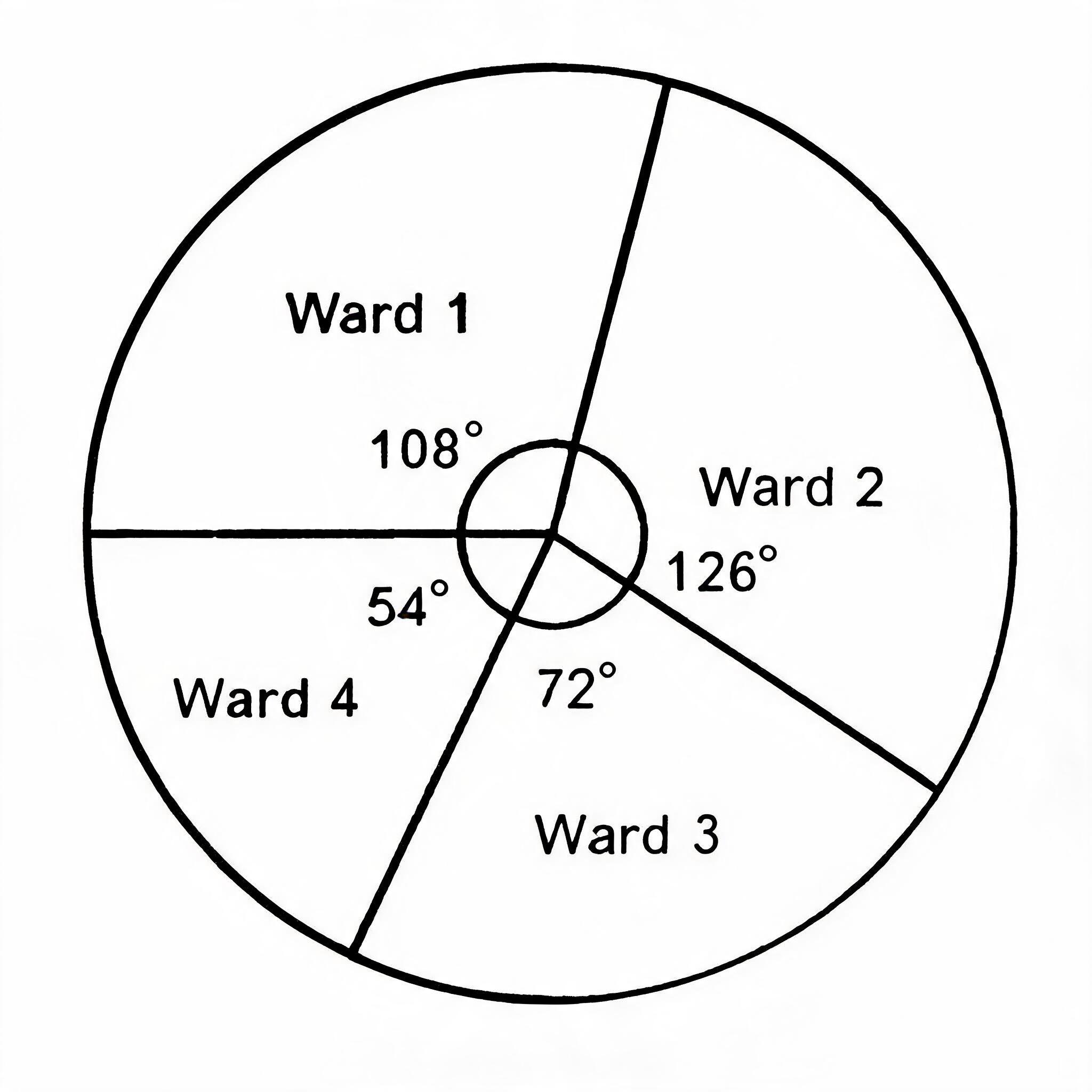
If the total population of the city is 500,000 what is the population of ward 4?
- A.75,000
- B.150,000
- C.125,000
- D.100,000
- E.50,000
The question requires you to calculate a value from the provided pie chart, which represents statistical data. The total angle in a circle is 360°, and the angle representing Ward 4 is 54°. To find the population of Ward 4, you calculate its proportion of the total population: (54° / 360°) x 500,000. This simplifies to 0.15 x 500,000, which equals 75,000.
Common mistake: Students might mistakenly use the angle for a different ward, such as Ward 1 (108°), which would lead to an incorrect answer of 150,000.
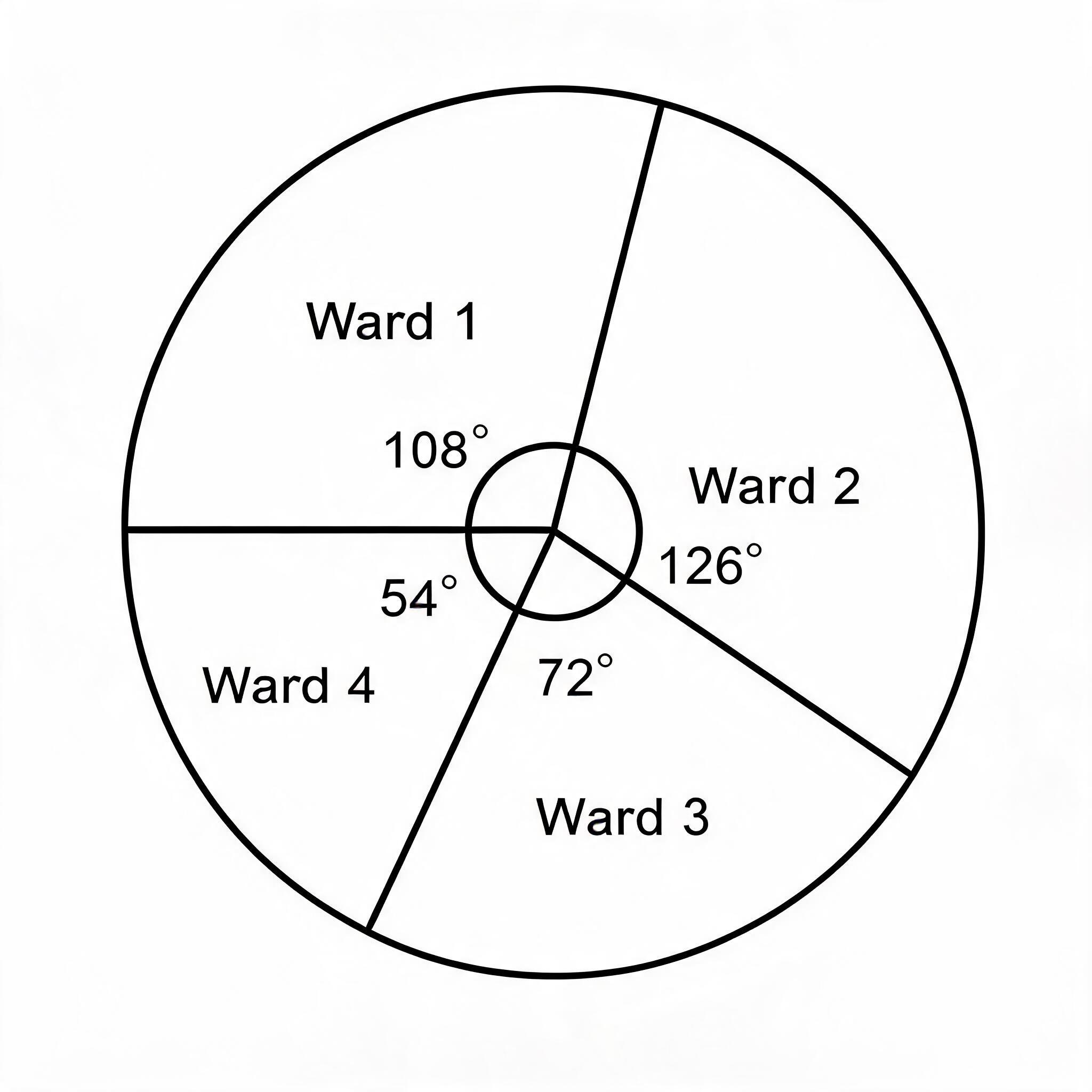
An alternative graphic method that can be used to depict that same information is the
- A.Divided rectangle
- B.Chloropath
- C.Dotman
- D.Proportinal circle
- E.Histograph
The image shows a pie chart, which is a graphic method used to represent proportional data for different categories, in this case, 'Wards'. A choropleth map (misspelled as 'Chloropath' in the option) is another geographical tool used to show statistical data for defined areas by using different shades or colours. Since the data is for different wards (which are geographical areas), a choropleth map is a very suitable alternative for showing the same information spatially.
Common mistake: Students may mistakenly choose 'Divided rectangle' because it also shows proportions like a pie chart, but it fails to represent the spatial or geographical aspect of the data which is tied to specific 'Wards'.
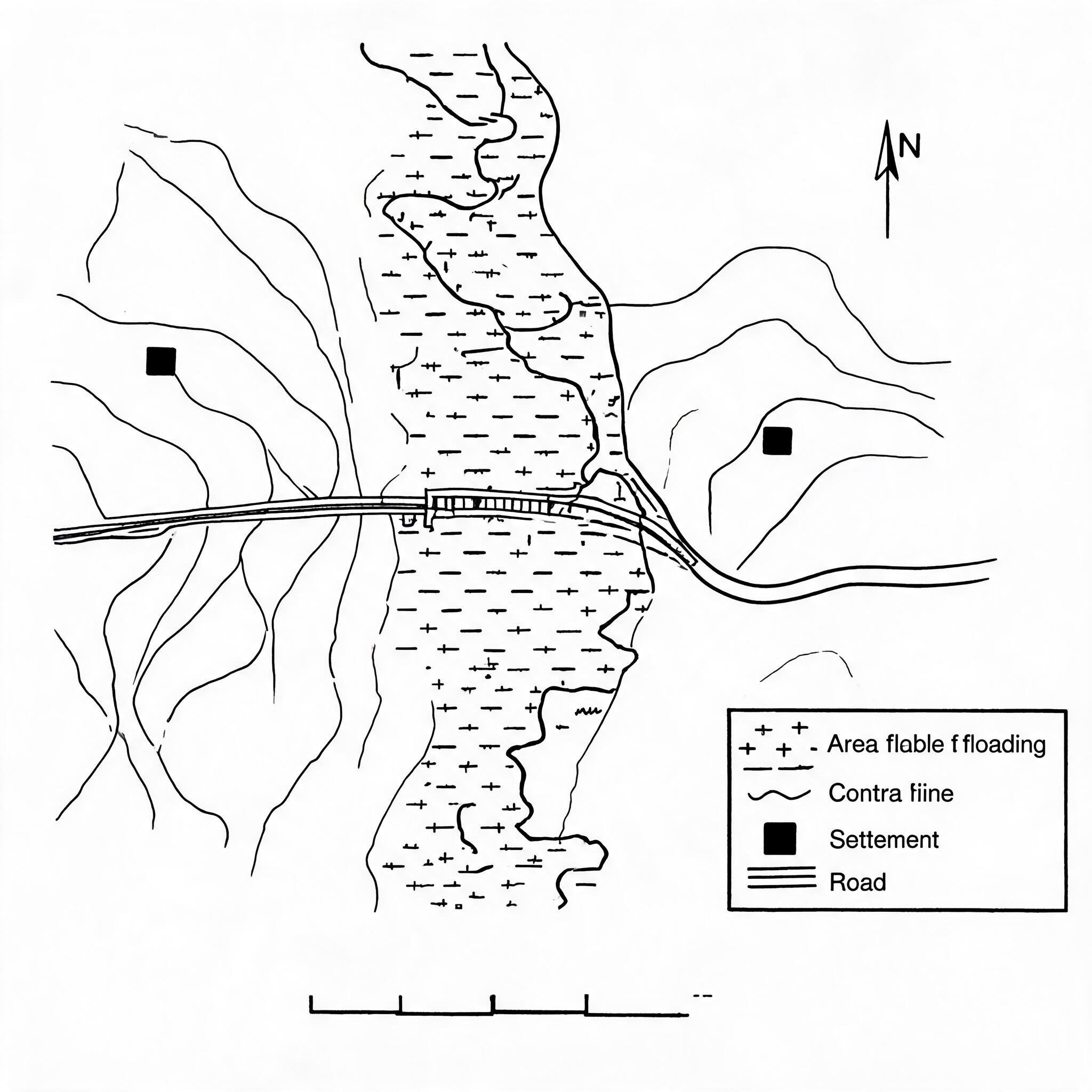
Area covered by the map is approximately

- A.125 km.sq
- B.105 km.sq
- C.95km.sq
- D.115 km.sq.
- E.100km.sq.
To find the area covered by the map, you multiply its length by its width. By using the grid lines shown on the map, where each square typically represents 1km by 1km, we can estimate the map's dimensions. The map extends approximately 11 kilometres from east to west (width) and about 10.5 kilometres from north to south (length), so multiplying these (11 km x 10.5 km) gives an area of 115.5 km², making 115 km² the closest answer.
Common mistake: A common mistake is to only count the number of full grid squares, such as 10 by 10 to get 100 km², and neglect to account for the partial squares along the map's edges.
The bearing of Jata from Adaba is approximately
- A.29°
- B.17°
- C.21°
- D.25°
- E.30°
To find the bearing of Jata from Adaba, you must first locate both towns on the provided map. You then place the center of a protractor on Adaba (the 'from' point) and align the 0-degree mark with the North line. The angle measured in a clockwise direction from this North line to the straight line connecting Adaba and Jata is approximately 21°.
Common mistake: A common mistake is to measure the bearing from Jata instead of Adaba, or to slightly misalign the protractor on the map, which could lead to choosing a close but incorrect option like 25° or 17°.
Intervisibility is possibility between the points marked X and Y because the intervening slope is
- A.Convex
- B.Rectilinear
- C.Convexo-concave
- D.Steep slope
- E.Concave
Intervisibility is the ability to see from one point to another without any obstruction. On a topographic map, this is determined by the shape of the land between the points. While a concave slope is the classic example that allows intervisibility, a steep and uniform (rectilinear) slope, shown by closely and evenly spaced contours, also provides a clear line of sight because there is no upward bulge of land to block the view.
Common mistake: Students often mistakenly choose 'A. Convex' because they confuse it with a concave slope; a convex slope bulges outwards and always blocks the line of sight, making intervisibility impossible.
The landform feature at the center of the map can best be described as
- A.A flood plain
- B.An erosional
- C.An outwash plain
- D.A deltaic plain
- E.Depositional plain
The question requires identifying a landform by interpreting a topographic map. The map shows a river flowing through a very wide, flat area, which is marked with symbols representing a swamp or marsh. This combination of a flat plain alongside a river, which is subject to periodic flooding and sediment deposition, is the definition of a floodplain.
Common mistake: Students might mistakenly choose 'Depositional plain' because a floodplain is indeed formed by deposition, but 'floodplain' is the more specific and correct term for a plain found alongside a river.
Given that the area show on the map is in Northern Nigeria, which of the following crop combinations would best be cultivated in the area that is liable to flooding?
- A.Banana, Rice, and Cassava
- B.Cassava, Rice, and Yam
- C.Sugarcane, Rice, and Cassava
- D.Sugarcane, Rice, and Bannans
- E.Cassava, Beans, and Cocoyam
The question requires identifying crops suitable for a flooded area in Northern Nigeria, as depicted on the map. The map shows a large floodplain or marshy area, indicated by the swamp symbols. These areas, known as 'fadama' in Northern Nigeria, are waterlogged for significant parts of the year. Sugarcane and rice are classic crops that thrive in such waterlogged conditions, while bananas also require a lot of water, making this combination the most suitable for the environment shown.
Common mistake: Students might mistakenly choose option C because it includes both sugarcane and rice, but they often forget that cassava does not tolerate prolonged flooding as its tubers will rot in waterlogged soil.
How were the major mountain belts of the world produced?
- A.By weathering
- B.By wind erosion
- C.By folding
- D.By river deposition
- E.By glacial erosion
The major mountain belts of the world, like the Himalayas and the Alps, are fold mountains. They were formed by a process called folding, which occurs when two of the Earth's tectonic plates collide and push against each other. This immense pressure causes the rock layers to bend, buckle, and uplift, creating the massive mountain ranges we see today.
Common mistake: Students might mistakenly choose weathering or erosion because these processes shape mountains, but they actually wear mountains down rather than build them up from scratch.
Along which latitude will the day time be the longest on Christmas day?
- A.0°
- B.45°S
- C.45°N
- D.30°N
- E.30°S
On Christmas day (December 25th), the Earth is near its December solstice position, where the Southern Hemisphere is tilted towards the sun. This causes summer in the Southern Hemisphere, resulting in longer days and shorter nights. As you move further south from the equator during this time, the length of the daytime increases. Therefore, of the options provided, 45°S is the southernmost latitude and will experience the longest day.
Common mistake: Students may mistakenly choose a latitude in the Northern Hemisphere like 45°N, forgetting that during December, the Northern Hemisphere is tilted away from the sun and experiences its shortest days.
Which is commodity associated with OPEC?
- A.Coffee
- B.Iron and Steel
- C.Vegetable oil
- D.Mineral oil
- E.Sugar
OPEC stands for the Organization of the Petroleum Exporting Countries. This is an international organization formed by countries, including Nigeria, whose main export is petroleum, which is also known as crude oil or mineral oil. These member countries work together to manage the supply and price of mineral oil in the world market. Therefore, mineral oil is the commodity directly associated with OPEC.
Common mistake: Students might mistakenly choose 'Iron and Steel' because it is also a major industrial resource, but OPEC deals exclusively with petroleum (mineral oil).
See all 40 JAMB Geography 2018 questions
Sign up free to unlock every question in this paper — with the verified answer and Beta's worked explanation on each one. No card needed to begin.
Start free