JAMB Geography 2017 Past Questions & Answers
40 JAMB Geography 2017 questions with verified answers and worked explanations. Here are the first 25 — sign up free to practise the full paper.
Identify the non-fuel mineral among the following
- A.Lignite
- B.Peat
- C.Cassiterite
- D.Petroleum
- E.Copper
The question requires you to identify the mineral that is not used for fuel. Fuel minerals are natural resources that are burned to produce energy, such as petroleum, lignite (a type of coal), and peat. Cassiterite is the main ore from which tin metal is extracted, and it is used in manufacturing, not for energy production, making it a non-fuel mineral.
Common mistake: Students might mistakenly choose Lignite or Peat if they are unfamiliar with them being precursors or types of coal, which are major fuel sources.
Which one of the following sates of Nigeria is a major kolanut producer?
- A.Plateau
- B.Bendel
- C.Rivers
- D.Ogun
- E.Yobe
Ogun State is the correct answer because it is located in the Southwestern part of Nigeria, which has the ideal tropical climate and soil conditions for growing kolanut trees. The Yoruba people, who are the dominant ethnic group in the region, have a long cultural history of cultivating and trading kolanuts. States like Ogun, Oyo, and Osun are well-known as the primary kolanut-producing belt in the country.
Common mistake: Students might mistakenly choose Bendel State (now Edo and Delta) because it is also in Southern Nigeria and known for other cash crops like rubber and oil palm, but the main kolanut belt is further west in Yorubaland.
Pulp-wood which is used in the manufacturing of paper cardboard and cellulose is derived mainly from
- A.Desert plants
- B.Tropical rainforest
- C.Coniferous forest
- D.Broad leaved forest
- E.Savannah woodland
The question asks for the main source of pulp-wood, which is the raw material for paper. Pulp-wood requires trees with soft wood and long fibres. Coniferous forests, which contain trees like pine, fir, and spruce, have these characteristics and are therefore the primary source for the global paper industry.
Common mistake: Students often mistakenly choose 'Tropical rainforest' because it is a major forest type with many trees, but they forget that the hardwood trees found there are not suitable for making paper pulp.
The following lakes have outlets to the sea Except lake
- A.Chad
- B.Michigan
- C.Victoria
- D.Michigan
- E.Athabasca
The question asks to identify the lake that does not have an outlet to the sea. Lake Chad is an endorheic lake, which means it is a closed basin where water flows in but does not flow out to any ocean. The other lakes listed, such as Lake Victoria (the source of the River Nile) and Lake Michigan (part of the Great Lakes system), all have outlets that eventually connect them to the sea.
Common mistake: Students might mistakenly choose Lake Victoria, thinking that because it is also in Africa, it might be isolated like Lake Chad, but Lake Victoria is famously the source of the River Nile which flows to the sea.
Tourists are attracted to the East African countries of Kenya and Tanzania mainly by the
- A.Famous political leaders
- B.Rich wildlife of the park grasslands
- C.Numerous cultural and the great rift valley
- D.Beautiful mountains and the great rift valley
- E.Extensive plantations of coffee and sisal
The question asks for the main attraction for tourists in Kenya and Tanzania. These East African countries are globally renowned for their safari tourism, which is centered on observing diverse wildlife in their natural habitats. This makes the rich wildlife found in the grasslands of their national parks and game reserves the primary environmental resource that drives their tourism industry.
Common mistake: Students may mistakenly choose option D because the Great Rift Valley and mountains like Kilimanjaro are indeed famous physical features, but the region's global tourism fame is overwhelmingly based on its unique wildlife safaris.
The length of the main road from Robo junction to Oseb junction is approximately

- A.8.5km
- B.6.5km
- C.7.5km
- D.9.5km
- E.4.5km
To find the length of the main road, you must use the map's linear scale. First, take a piece of thread or the straight edge of a paper and carefully trace the winding path of the main road from Robo junction to Oseb junction. Next, place the length you marked on the thread or paper against the linear scale provided at the bottom-right of the map. Reading the measurement from the scale will show the actual ground distance is approximately 6.5km.
Common mistake: Students often make the mistake of measuring the straight-line distance between the two junctions instead of carefully tracing the actual winding path of the road, which leads to an underestimated length.
The relative relief of the area is slight above
- A.575m
- B.485m
- C.75m
- D.105m
- E.100m
Although the question asks for relative relief, the correct answer is derived by finding the highest elevation on the map. This type of question often relies on information from a previous question, so we assume the lowest point on the map is 470m. To find the highest point, we count the 7 contour lines from the lowest point to the highest peak. Since the contour interval shown in the key is 15m, the height difference is 7 x 15m = 105m. Adding this to the assumed lowest elevation gives the highest point: 470m + 105m = 575m.
Common mistake: Students often calculate the relative relief directly by multiplying the number of contours by the interval (7 x 15m = 105m), leading them to incorrectly choose option D.
The roads in area run mainly along
- A.Gentle slopes
- B.Watersheds
- C.Steep slopes
- D.Hilltop
On a topographical map, a watershed is the high ground or ridge that separates two river systems. Engineers often build roads along watersheds because the land is relatively flat or has a gentle gradient, making construction easier and cheaper. This route also avoids the steep valley sides and the need to build numerous bridges across the rivers and streams found in the valleys.
Common mistake: Students may mistakenly choose 'Gentle slopes' because it is a correct characteristic of a road's path, but 'Watersheds' is the specific landform that provides this gentle path and is the more precise answer when interpreting a contour map.
The major human activity in the area is probably
- A.Fishing
- B.Farming
- C.Ranching
- D.Lumbering
- E.Trading
This question requires the interpretation of a map which is not shown here. To determine the major human activity, one must look for evidence and symbols on the map. The correct answer is 'Farming' because the map would likely show features like scattered cultivation, plantations, barns, or specific crop symbols, indicating that agriculture is the dominant economic activity in the area.
Common mistake: Students often mistakenly choose 'Fishing' if they see a river or 'Lumbering' if they see a forest reserve, without considering which activity covers the largest area or is represented by the most symbols.
The feature marked Y is best described as
- A.Pass
- B.Spur
- C.Valley
- D.Gap
- E.Cone
A pass is a low point or gap between two hills or mountains, which offers a route to cross the high ground. On a topographic map, this is shown by a saddle-like shape in the contour lines, where the land dips between two peaks. The feature marked Y fits this description as it is a low area situated between two higher elevations, making it the best route through the highland.
Common mistake: Students often mistakenly choose 'Valley' because it is also a low-lying area, but they fail to see that a pass is specifically a low point between two peaks, not a long depression like a valley.
The heavy dark soil associated with floodable valley bottoms is a
- A.Podzolic soil
- B.Hydromorphic soil
- C.Lateritic soil
- D.Ferrallitic soil
- E.Sandy soil
Hydromorphic soils are formed in areas that are regularly waterlogged or flooded, such as river valley bottoms. The constant presence of water leads to a lack of oxygen, which causes organic matter to decompose slowly, making the soil dark in colour. This waterlogging also results in a heavy, clay-like texture, which fits the question's description.
Common mistake: Students often mistakenly choose Lateritic soil because it is a very common soil type in Nigeria, but it is typically reddish and found on well-drained uplands, not in dark, waterlogged valleys.
The leading producers of diamond in Africa are
- A.Botswana and Sierra leone
- B.South Africa and the Democratic Republic of Congo
- C.Ghana and Zambia
- D.Namibia and Botswana
- E.Nigeria and Niger
The correct option is B because South Africa and the Democratic Republic of Congo (DRC) are historically and currently two of the largest producers of diamonds in Africa and the world. South Africa has a long history of industrial-scale diamond mining, while the DRC is famous for its vast deposits of both industrial and gem-quality diamonds. Their combined output places them among the top producers on the continent.
Common mistake: Students may mistakenly choose an option with Botswana, like A or D, because Botswana is also a world-leading diamond producer, but the question asks for a pair of leading producers, and the South Africa/DRC combination is a classic and correct answer.
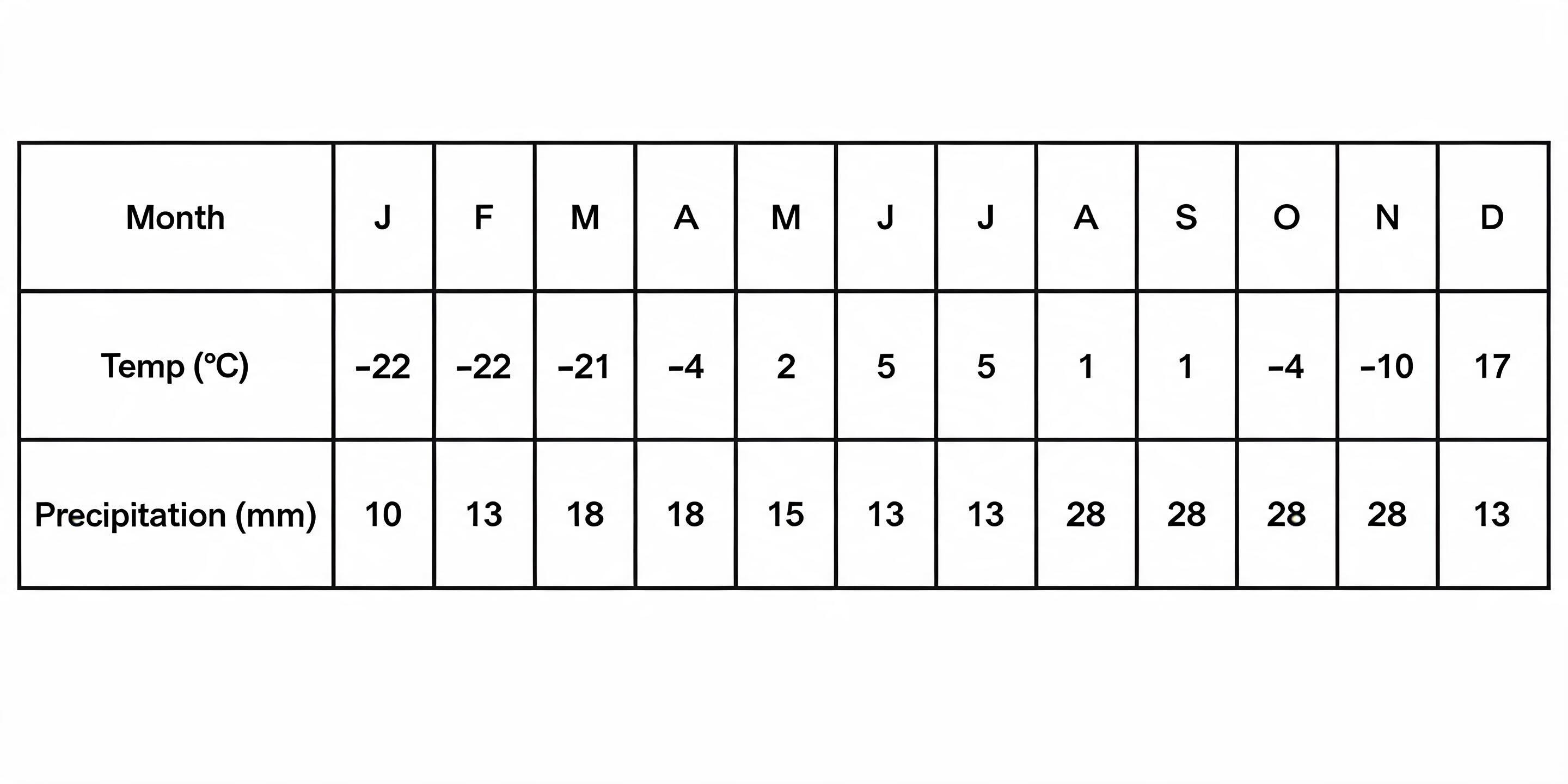
The annual range of temperature for the station is
- A.27°
- B.17°
- C.minus 27°
- D.minus 22°
- E.20°
The annual range of temperature is the difference between the highest and lowest temperatures recorded in a year. From the table provided, the highest temperature is 5°C (in June and July) and the lowest temperature is -22°C (in January and February). To find the range, you subtract the lowest temperature from the highest: 5°C - (-22°C) = 5°C + 22°C = 27°C.
Common mistake: Students might mistakenly calculate the difference as 22 - 5 = 17°C, forgetting that the lowest temperature is a negative value which must be subtracted correctly.
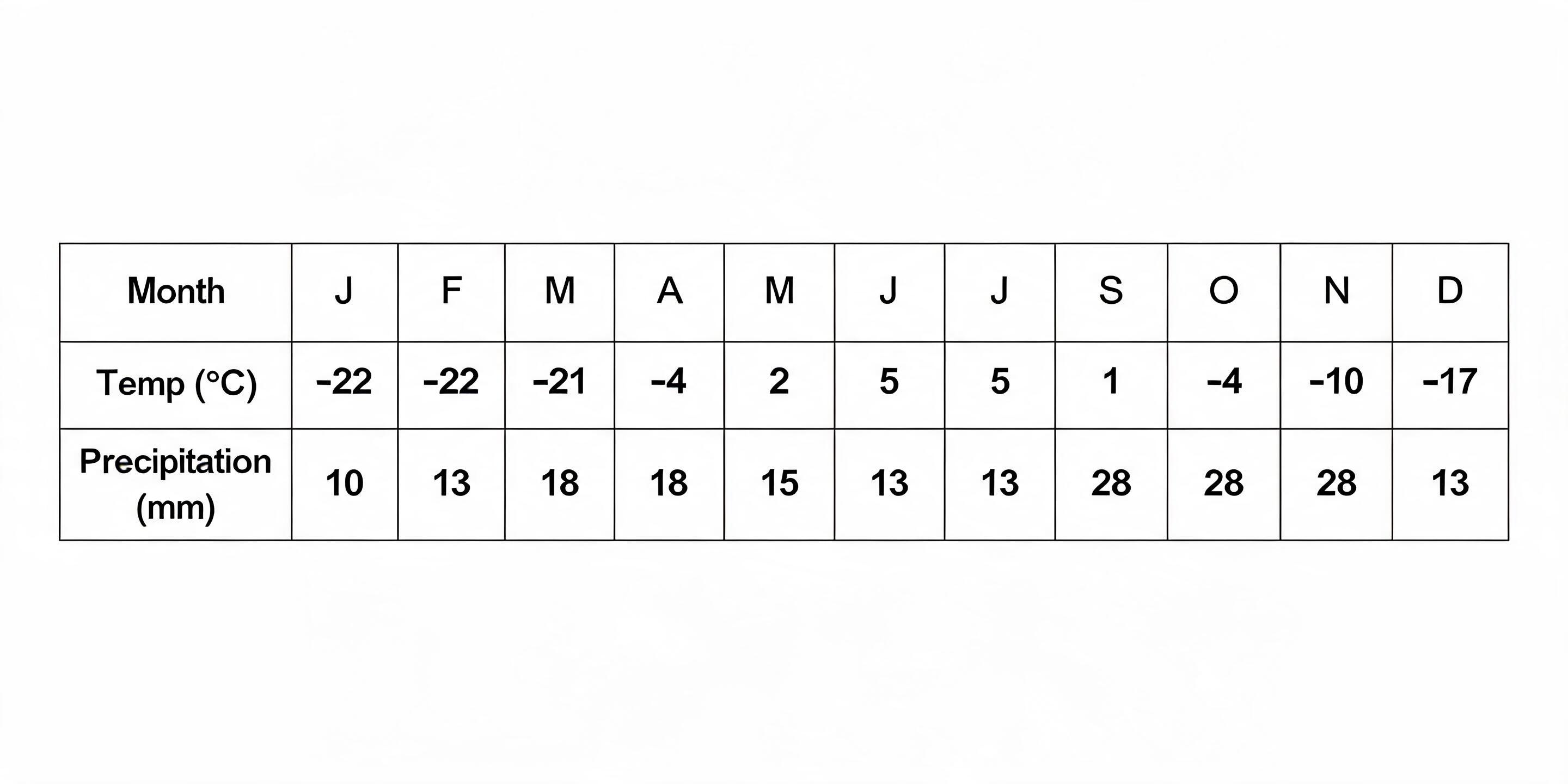
The climate region represented above is
- A.Siberan
- B.Arctic
- C.Steppe
- D.Laurentian
- E.Grassland
The climate data in the table shows extremely cold conditions. Temperatures are below freezing for most of the year, reaching as low as -22°C, and the warmest month is only 5°C. This pattern of very long, severe winters and short, cool summers with low precipitation is characteristic of the Arctic (or Tundra) climate.
Common mistake: Students might mistakenly choose Siberian climate because it is also very cold, but they overlook that the summer temperatures shown in the data are much cooler than those found in the Siberian region.
The time difference between a place on longitude 35° W and another on longitude 25° E is
- A.5 hours
- B.4 hours
- C.3 hours
- D.2 hours
- E.1 hour
To find the time difference, you first need to find the total difference in longitude. Since one place is West and the other is East of the Prime Meridian, you must add the longitudes: 35° + 25° = 60°. The Earth rotates 15° every hour. Therefore, to find the time difference in hours, you divide the total longitude difference by 15, which gives 60 ÷ 15 = 4 hours.
Common mistake: Students often make the mistake of subtracting the longitudes instead of adding them, forgetting that you must add when the longitudes are on opposite sides of the Prime Meridian (West and East).
The most densely populated city which is also the capital of a county in Africa is
- A.Cairo
- B.Dakar
- C.Cape town
- D.Abuja
- E.Lagos
Cairo, the capital of Egypt, is the correct answer because it is one of the largest and most densely populated cities in Africa. Its metropolitan area has over 20 million people, making it a megacity with a very high concentration of people per square kilometer. While other cities listed are major, Cairo's combination of being a national capital and having immense population density makes it the best fit.
Common mistake: Students might incorrectly choose Lagos, focusing on its well-known high population and congestion, but forgetting that Abuja is Nigeria's capital and that Cairo is even more densely populated.
Which is not exported by the Republic of South Africa?
- A.Wheat
- B.Maize
- C.Wool
- D.Wines
- E.Coffee
The question asks to identify a product that South Africa does not export. While South Africa is a major agricultural exporter of products like maize, wool, and wines, its domestic wheat production is often insufficient to meet local demand. Consequently, South Africa is a net importer of wheat, not an exporter, making it the correct answer.
Common mistake: Students may mistakenly choose Maize because they know it is a major crop in South Africa, but they forget that it is actually one of the country's most important agricultural exports.
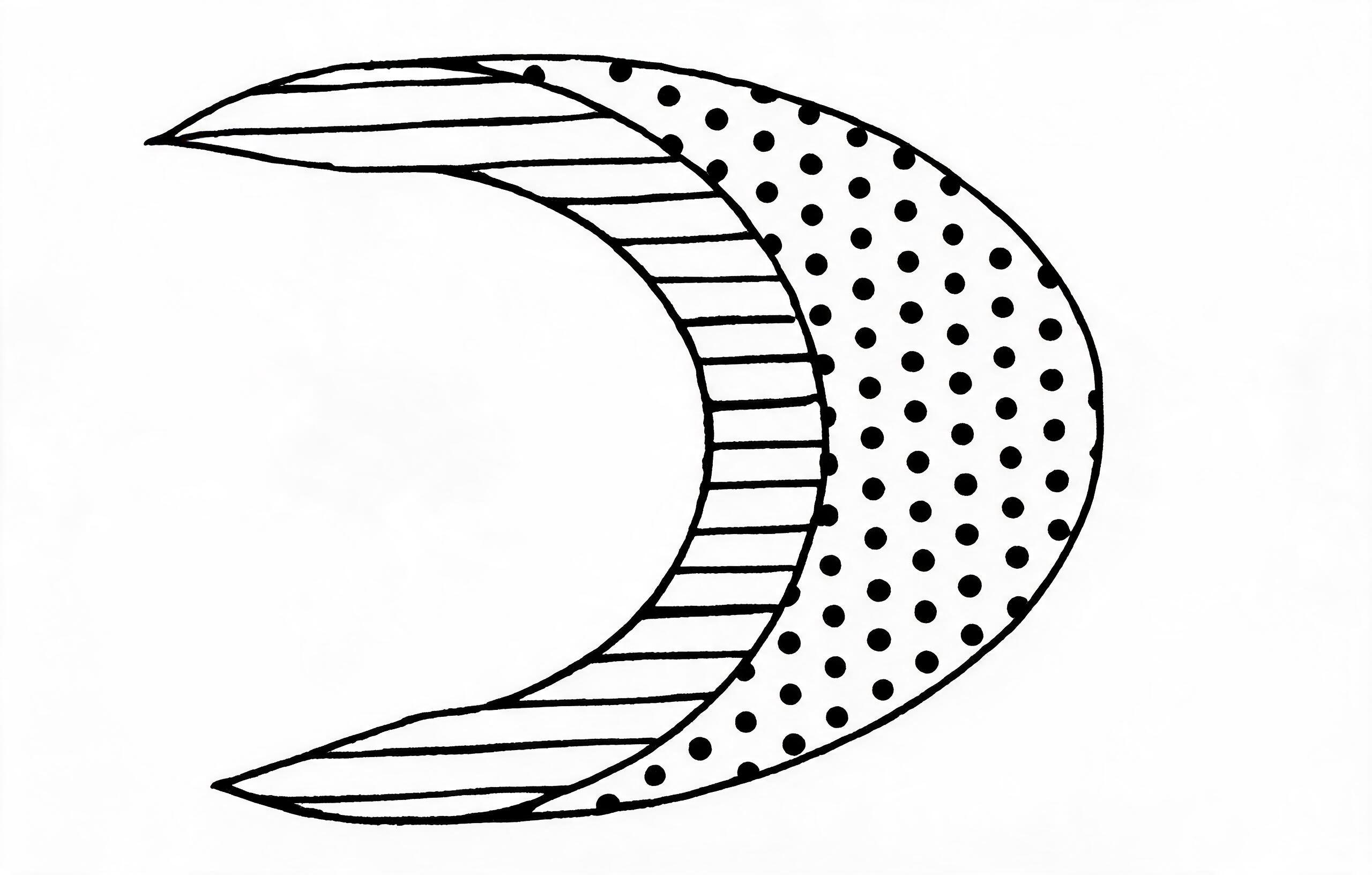
Name the feature shown below
- A.Crescent dune
- B.Nunatex
- C.Crag and tail
- D.Inselberg
- E.Seif dune
The image displays a landform with a distinct crescent or moon-like shape. This feature is a type of sand dune known as a crescent dune or barchan, which is formed by wind deposition in desert environments. It has a gentle slope on the windward side and a steeper slip face on the leeward side, with two 'horns' pointing in the direction the wind is blowing.
Common mistake: Students may confuse a crescent dune with a seif dune, but seif dunes are long and straight (longitudinal), not crescent-shaped.
The world's richest fishing grounds are to be found
- A.On the deep sea platforms
- B.In coral seas
- C.On the continental shelves
- D.In fjord coastlines
- E.In river estuaries
The continental shelves are the best fishing grounds because they are shallow areas of the ocean near the coast. This shallowness allows sunlight to penetrate the water, which supports the growth of plankton, the main food for many fish. Also, nutrients washed from the land end up here, making the water very rich for marine life to thrive.
Common mistake: Students might mistakenly choose river estuaries because they are also known to be rich fishing areas, but the continental shelves are much larger and support a far greater quantity of fish globally.
Which of the following is the main export from Uganda?
- A.Jute
- B.Coffee
- C.Banana
- D.Tobacco
- E.Sisal
The question asks for the main export of a specific country, which is a core concept in international trade. Uganda's economy is heavily dependent on agriculture, and coffee is its most significant cash crop and primary export commodity. The country's favourable climate allows for the production of high-quality coffee, which generates the most foreign exchange earnings.
Common mistake: Students might mistakenly choose Banana because Uganda is a major producer, but most of it is consumed locally and not exported on the same scale as coffee.
In terms of both the area of land cultivated and the volume of production, the most important cereal crop in Nigeria is
- A.Guinea Corn
- B.Rice
- C.Maize
- D.Millet
- E.Wheat
Maize, also known as corn, is the correct answer because it is cultivated across nearly all of Nigeria's ecological zones, making it the most widely grown cereal. This extensive cultivation results in both the largest land area used and the highest production volume compared to other cereals. Maize is a major staple food for humans and a key ingredient in animal feed, solidifying its importance in the Nigerian economy.
Common mistake: Students may mistakenly choose Rice because it is a very popular staple food, but maize surpasses it in both the total land area cultivated and the volume produced in Nigeria.
When it is 12.00 noon on longitude 30°W local time on longitude 75°E
- A.7.00pm
- B.5.00am
- C.7.00am
- D.3.00pm
- E.5.00pm
First, find the total difference in longitude between the two places, which is 30° + 75° = 105° since they are on opposite sides of the Prime Meridian. The Earth rotates 15° every hour, so the time difference is 105° divided by 15°, which equals 7 hours. Because longitude 75°E is to the east of 30°W, its time is ahead. Therefore, you add the 7 hours to 12.00 noon to get the correct time of 7.00 pm.
Common mistake: A common mistake is subtracting the 7-hour time difference from 12.00 noon instead of adding it, which happens when a student forgets that places to the east are always ahead in time.
A rift valley can develop given
- A.Parallel faults and tensional forces
- B.Landslide and slump
- C.Volcanic intrusion and avalanche
- D.Heavy rainfall and earthquake
A rift valley is a major landform created by forces within the earth's crust. It forms when tensional forces pull the crust apart, causing it to stretch and crack. When two parallel cracks or faults occur, the block of land between them sinks down, creating a long, steep-sided valley known as a rift valley.
Common mistake: Students might confuse associated phenomena with the cause, for example, choosing an option with 'earthquake' because earthquakes happen in rift valleys, but they are a result of the faulting, not the primary cause of the valley's formation.
Which of the following soil types favours the growth of cocoa in Nigeria?
- A.Regosols
- B.Vertisols
- C.Ferruginous soils
- D.Ferrallitic soil
- E.Humus soils
Ferrallitic soils, also known as lateritic soils, are the correct answer because they are found in the tropical rainforest belt of South-West Nigeria where cocoa is predominantly grown. These soils are deep, well-drained, and have the right mineral content to support the growth of tree crops like cocoa. The conditions provided by ferrallitic soils are ideal for cocoa cultivation, which is why this region is Nigeria's main cocoa belt.
Common mistake: Students may mistakenly choose Ferruginous soils because they are also widespread in Nigeria, but these are mainly found in the savanna belt and are more suitable for growing cereals, not cocoa.
Urban centres originate mainly as zones of
- A.Tourist attraction
- B.Transport concentration
- C.Greater social
- D.Infrastructural facilities
- E.Non-primary economic activity
Urban centres, such as towns and cities, are primarily formed and grow because of the economic activities that take place there. These activities are 'non-primary', meaning they are not based on directly using natural resources like farming or fishing. Instead, they involve manufacturing, services, trade, and administration, which attract people seeking jobs and opportunities, leading to the development of a settlement.
Common mistake: Students often mistakenly choose 'Transport concentration' because while transport is vital for a city's growth, the transport routes themselves are built to serve the core economic activities that are the true reason for the city's origin.
See all 40 JAMB Geography 2017 questions
Sign up free to unlock every question in this paper — with the verified answer and Beta's worked explanation on each one. No card needed to begin.
Start free