JAMB Geography 2019 Past Questions & Answers
40 JAMB Geography 2019 questions with verified answers and worked explanations. Here are the first 25 — sign up free to practise the full paper.
What is a typical farmer in the Susan Savannah of Nigeria most likely to be doing in June?
- A.Taking part in a fishing festival
- B.Clearing his land for planting
- C.Resting because he has less to do
- D.Planting his main cash crop
- E.Harvesting his main cash crop
In the Sudan Savannah region of Nigeria, the rainy season typically begins around May or June. The first rains soften the ground, which is very hard and dry after the long dry season. This makes June the perfect time for a farmer to clear the land of weeds and prepare the soil for planting crops like millet, sorghum, and groundnut.
Common mistake: Students might mistakenly choose 'Planting his main cash crop' because planting also happens during the rainy season, but they forget that clearing the land is the first major activity that must be done before planting can begin.
Bamboo and mahogany, liana and obeche, raphia and tree ferns. In which vegetation type are all these found?
- A.Coniferous forest
- B.Tropical monsoon
- C.Tropical forest
- D.Sub-tropical forest
- E.Chaparral forest
The correct answer is Tropical forest because this vegetation belt is known for its incredible variety of plant life. The plants listed, such as mahogany and obeche (tall trees), lianas (climbing vines), and bamboo, are all classic examples of species that thrive together in the hot, wet conditions of a tropical rainforest. This rich mixture of different plant types is a key feature of this biome.
Common mistake: Students might mistakenly choose Tropical monsoon forest because it is also in the tropics, but it has a distinct dry season and a slightly different mix of plant species than the ever-wet tropical rainforest.
Which of the following is a correct pair?
- A.River/Cut-off
- B.Glacier/Erratic boulder
- C.Limestone/Pass
- D.Desert/Cavern
- E.Mountain/Stalagmite
The correct answer is A because a cut-off is a landform directly created by the action of a river. As a river meanders or winds, it can erode a new, shorter channel across a narrow piece of land, creating a 'cut-off'. The old, abandoned river loop often becomes an ox-bow lake, making this a classic example of a feature formed by river erosion.
Common mistake: Students might mistakenly choose option D, incorrectly associating large empty spaces like caverns with vast desert landscapes, when in fact caverns are formed underground by water dissolving limestone rock.
With which of the following processes are drumlins boulder clay and terminal moraines associated?
- A.River deposition
- B.Wind deposition
- C.Glacial erosion
- D.River erosion
- E.Glacial deposition
Glaciers are large, slow-moving masses of ice that scrape and carry rocks, sand, and clay. When a glacier melts or slows down, it drops or 'deposits' all the material it was carrying. These deposited materials form specific landforms, such as drumlins (oval-shaped hills), boulder clay (unsorted glacial sediment), and terminal moraines (ridges of debris at the glacier's furthest point). Therefore, all these features are created by the process of glacial deposition.
Common mistake: Students often mistakenly choose 'Glacial erosion' because they know glaciers are involved, but they confuse the process of wearing away land (erosion) with the process of building up landforms by dropping material (deposition).
Examples of folded structures in Africa include the Atlas Mountains, the Cape Ranges and the
- A.Jos Plateau
- B.Akwapim Hills
- C.Adamawa Highlands
- D.East Africa Rift
- E.Ruwenzori
Fold mountains are created when compressional tectonic forces cause the Earth's crust to buckle and fold upwards. The Atlas Mountains and the Cape Ranges are well-known examples of these structures in Africa. The Akwapim Hills in Ghana were also formed through this same folding process, making them the correct addition to the list.
Common mistake: Students often mistakenly choose the Ruwenzori mountains because they are a major African range, but they are block mountains formed by faulting, not by folding.
The highest point in the area depicted on the map is just above

- A.800m
- B.500m
- C.600m
- D.900m
- E.700m
To find the highest point, you must look for the highest contour line on the map. The contour interval (the difference in height between lines) is 100 metres, as seen from the labeled lines (100, 200, 300, 400). If you look at the hill in the top-left corner of the map, the last labeled line is 400m, but there are four more unlabeled lines inside it, representing 500m, 600m, 700m, and 800m. Therefore, the highest point on the map is the peak inside the 800m contour, making it just above 800m.
Common mistake: Students often make the mistake of only considering the highest labeled contour, which is 400m, and incorrectly assume the highest point is just above 400m or 500m.
The bearing, to the nearest degree, of the mosque in Amagu settlement from the middle of the bridge across the River Zogo is
- A.41°
- B.51°
- C.61°
- D.31°
- E.71°
To find the bearing, first locate the starting point on the map, which is the middle of the bridge over River Zogo. Next, locate the destination, the mosque in Amagu settlement. Imagine or draw a straight line pointing North from the bridge, then draw another straight line connecting the bridge to the mosque. The bearing is the angle measured clockwise from the North line to the line connecting the two points, which is approximately 61°.
Common mistake: A common mistake is to measure the bearing of the bridge *from* the mosque, which would give the back bearing, instead of measuring from the bridge *to* the mosque as the question asks.
The feature through which the River Ngu flows ar XX is known as a
- A.Col
- B.Saddle
- C.Anticline
- D.Pass
- E.Gap
The question requires you to identify a landform from a contour map. The River Ngu is shown cutting through an elongated ridge. An anticline is an upward fold of rock layers that often forms a ridge after erosion. The river has carved a path, known as a water gap, through this anticlinal ridge, meaning the feature it flows through is the anticline itself.
Common mistake: Students often mistake this for a 'Gap' or 'Pass', which are correct topographic terms for the opening, but the question asks for the larger geological structure that the river is cutting through.
The major relief feature between the rivers Zogo and Bidana is a
- A.Ridge
- B.Cuesta
- C.Mountain
- D.Hill
- E.Plateau
The question requires you to identify the landform between River Zogo and River Bidana on the topographical map. The contour lines in this area are elongated and show a long, narrow stretch of high land with elevations reaching over 400 metres. A long, narrow upland area that separates two valleys, like the ones the rivers flow in, is the definition of a ridge.
Common mistake: Students might choose 'Hill' because it is an area of high ground, but they may fail to recognize that the specific elongated shape shown by the contour lines defines a ridge, not an isolated or rounded hill.
Which of these statements does NOT correctly describe the relationship between settlements and relief in the area? The settlements are
- A.All spring-line settlements
- B.Located mainly in valleys
- C.Generally located on the summits
- D.Not on the immediate banks of the major streams
- E.Located at the foot-slopes
The question asks you to identify the statement that is FALSE based on the information on the topographical map. If you look closely at the map, you will see settlements like Amagu, Zogo, and Ebede located right beside the rivers (R. Ngu, R. Zogo, and R. Danda). This means that some settlements are in fact on the immediate banks of the streams. Therefore, the statement in option D, which says the settlements are 'Not on the immediate banks of the major streams', is an incorrect description of the map and is the correct answer.
Common mistake: Students might mistakenly choose option C because it is also a false statement (no settlements are on the summits), but option D is a more direct contradiction as several settlements are clearly shown on the river banks.
The pair of countries which has the largest area of coniferous forest in the world is made up of Canada and
- A.The U.S.A
- B.New Zealand
- C.Brazil
- D.The U.S.S.R
- E.Norway
This question is about the global distribution of major vegetation types. Canada is known for its massive boreal forest, which is a type of coniferous forest. New Zealand, located in the Southern Hemisphere, also has significant temperate rainforests that are rich in unique native coniferous trees like the Kauri and Rimu. The question pairs these two countries to represent major, though different, coniferous forest zones in both the Northern and Southern Hemispheres.
Common mistake: Many students will choose the U.S.S.R. (Russia) because it has the world's largest coniferous forest, but they might overlook the specific pairing logic intended by the examiner which considers significant zones in both hemispheres.
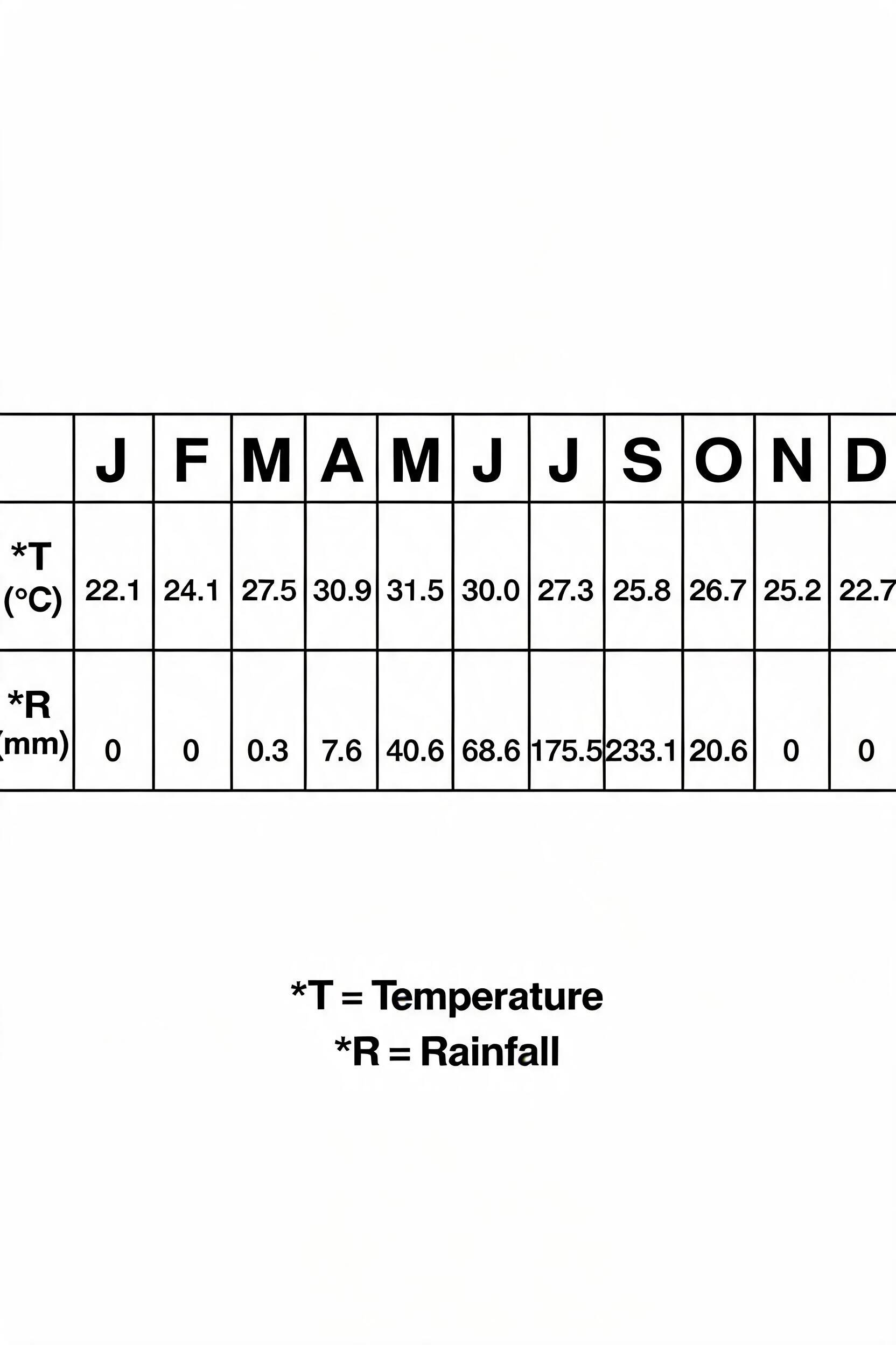
Study the table below, which shows the mean climatic conditions at Station Y , and answer question 12 to 14
"Adiabatic cooling" is the cooling of rising air as a result of
- A.Movement on the windward side of mountains
- B.Increasing altitude
- C.Instability
- D.Advection
- E.Expansion and internal loss of heat
Adiabatic cooling is the process where a parcel of air cools as it rises without losing heat to its surroundings. As air moves to a higher altitude, the atmospheric pressure decreases, allowing the air parcel to expand. This expansion requires energy, which is taken from the air parcel itself, causing its temperature to drop.
Common mistake: Students may mistakenly choose option E, 'Expansion and internal loss of heat', because it correctly describes the physical mechanism, but the fundamental reason for this expansion in the atmosphere is the decrease in pressure that occurs with increasing altitude.
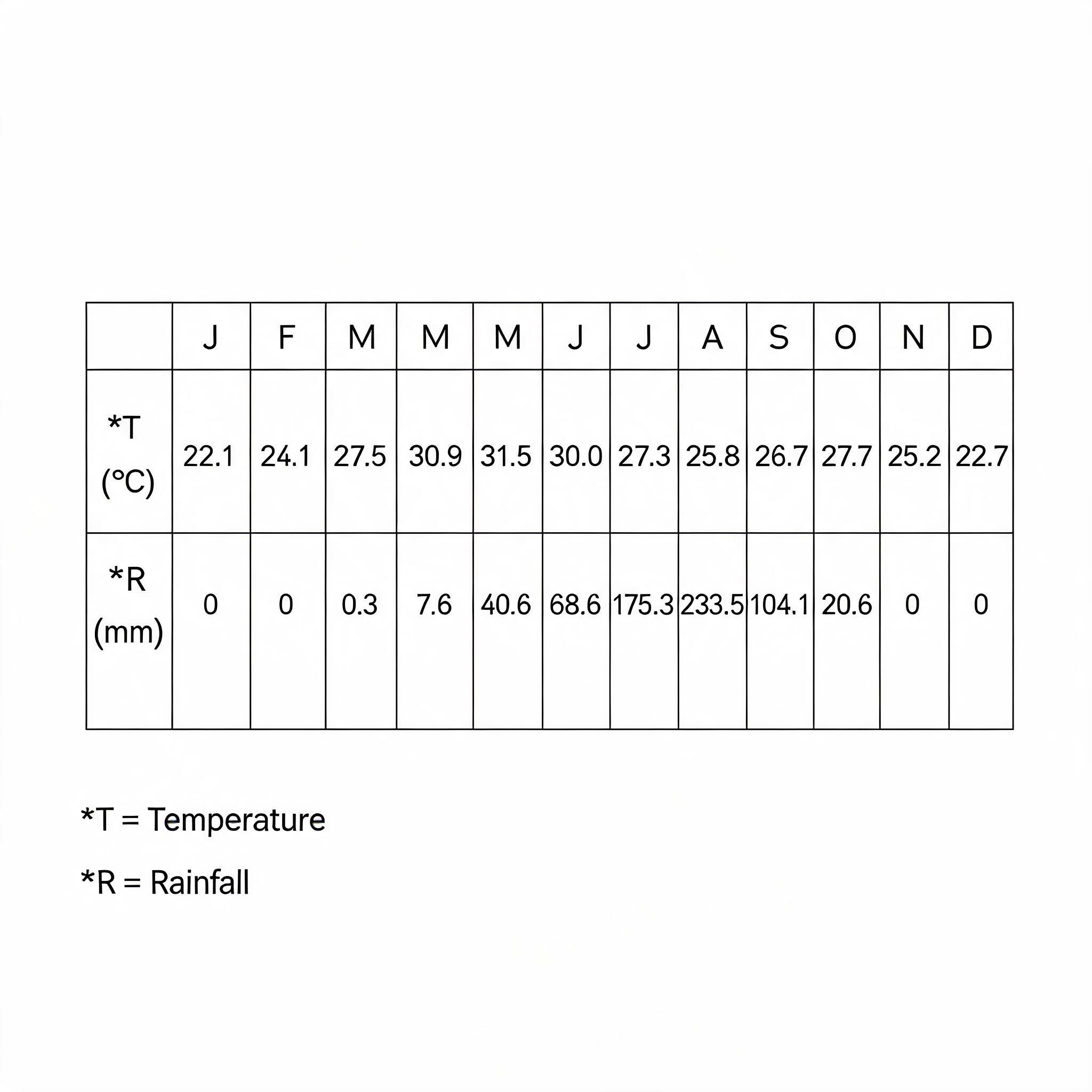
Study the table below, which shows the mean climatic conditions at Station Y , and answer question 12 to 14
Station Y is located in the Northern Hemisphere because the
- A.Highest rainfall is in August
- B.Annual range of temperature is 9.4°C
- C.Coolest period is from November to February
- D.Rainfall pattern is seasonal
- E.Temperature of the warmest month is 31.5°C
The Northern Hemisphere experiences its winter, or coolest season, during the months of November, December, January, and February because it is tilted away from the sun. By examining the temperature data in the provided table, we can see that the lowest temperatures for Station Y occur in January (22.1°C) and December (22.7°C). This timing of the cool season directly proves that the station is located in the Northern Hemisphere.
Common mistake: Students might incorrectly choose option A because the peak rainfall in August is a familiar pattern for West Africa, but the timing of temperature seasons is the most reliable and fundamental indicator of a hemisphere.
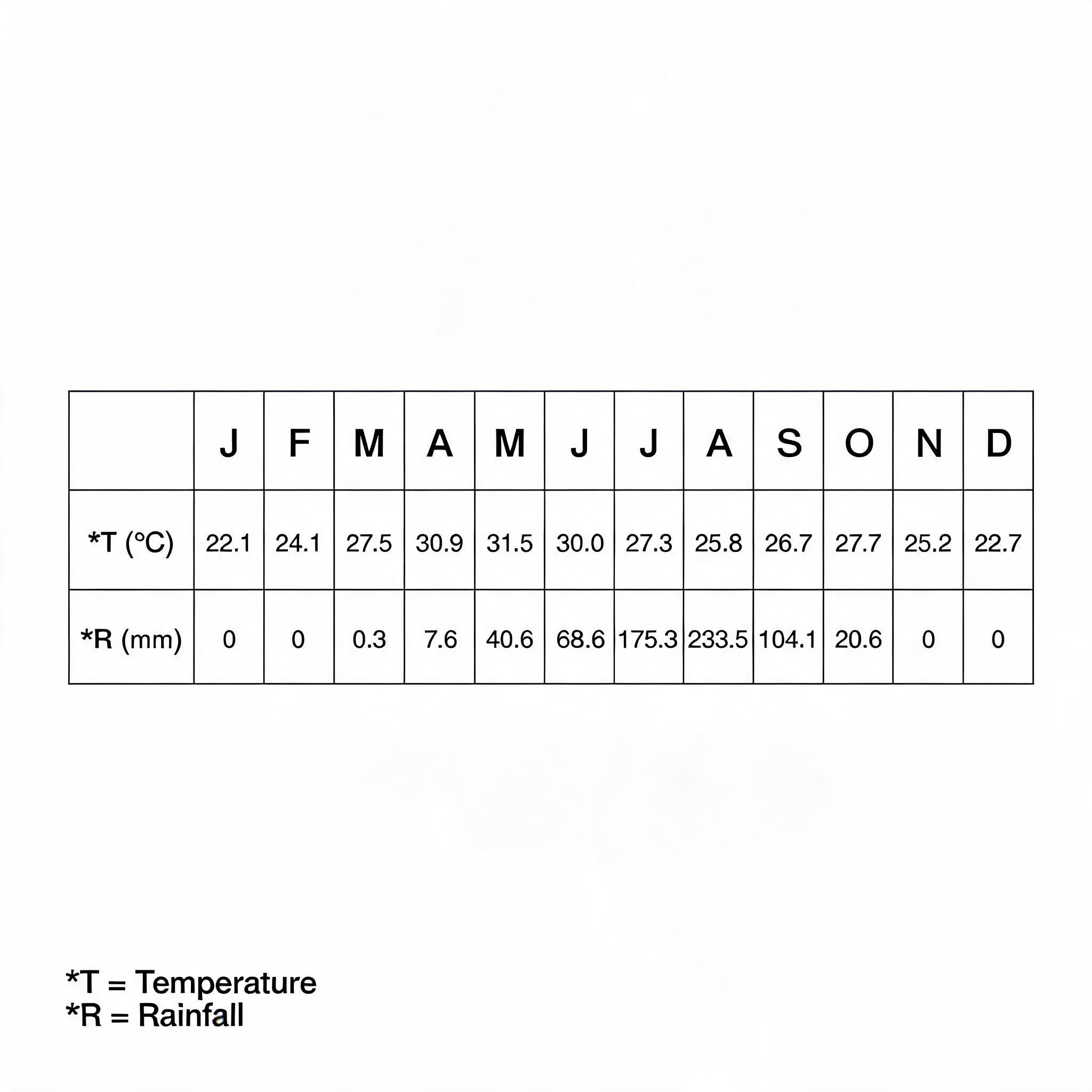
Study the table below, which shows the mean climatic conditions at Station Y , and answer question 12 to 14
The mean temperature of Station Y is
- A.27.3°C
- B.31.5°C
- C.30.0°C
- D.26.8°C
- E.22.1°C
To find the mean temperature, you must add all the monthly temperature values from the table and then divide by the total number of months, which is 12. The sum of the temperatures is 22.1 + 24.1 + 27.5 + 30.9 + 31.5 + 30.0 + 27.3 + 25.8 + 26.7 + 27.7 + 25.2 + 22.7 = 321.5°C. Dividing this total by 12 gives 321.5 / 12 = 26.79°C, which is approximately 26.8°C.
Common mistake: Students might mistakenly choose the highest monthly temperature (31.5°C) instead of calculating the average of all twelve months.
The mean annual rainfall of Station Y is
- A.175.3mm
- B.54.2mm
- C.650.8mm
- D.233.5mm
- E.408.8mm
To find the mean annual rainfall, you must first calculate the total rainfall for the year and then divide it by the number of months. Based on the options, the total annual rainfall (the sum of all monthly rainfall figures from the question's data table) is 650.8mm. To find the mean, you divide this total by 12 (the number of months in a year): 650.8mm / 12 = 54.23mm. The closest answer is therefore 54.2mm.
Common mistake: The most common mistake is to calculate the total annual rainfall (650.8mm) by summing all the monthly values and then incorrectly choosing that total as the answer (Option C), instead of dividing by 12 to find the mean.
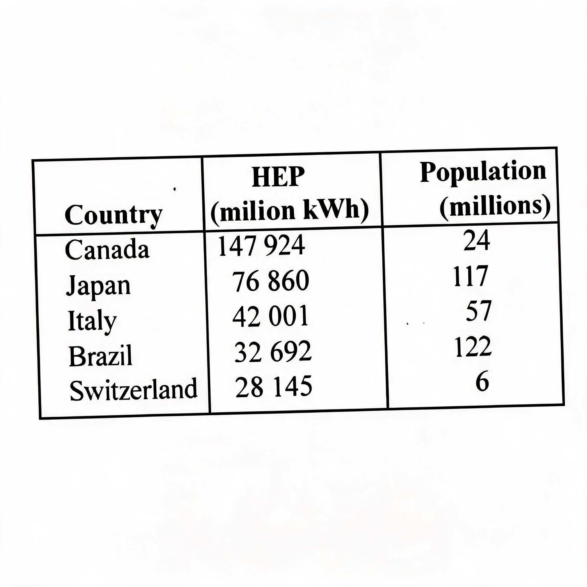
Which of the following observation can be inferred from the table above, which shows the hydro-electric power (HEP) development in some selected countries?
- A.Power from hydro-electricity is cheaper than power from other sources
- B.More factories use HEP in Brazil than in Switzerland
- C.Per capita HEP consumption is higher in Switzerland than in Italy
- D.More HEP stations are built in Canada than in Japan
To find the per capita (per person) consumption, you must divide the total HEP production by the country's population. For Switzerland, this is 28,145 million kWh divided by 6 million people, which equals about 4,691 kWh per person. For Italy, it is 42,001 million kWh divided by 57 million people, which is only about 737 kWh per person, proving that consumption per person is higher in Switzerland.
Common mistake: A common mistake is to only look at the total HEP production, see that Italy (42,001) produces more than Switzerland (28,145), and incorrectly assume its per capita consumption is also higher without considering the population difference.
Which of the following represents tha cheapest mode of transportation
- A.Air
- B.Rail
- C.Road
- D.Water
Water transportation is the cheapest mode for moving goods, especially heavy and bulky items over long distances. This is because ships and barges can carry massive quantities at once, which makes the cost per item very low. Also, unlike roads and railways that need to be built and maintained, oceans, seas, and many rivers are natural routes, which saves a lot of money on infrastructure.
Common mistake: Students often mistakenly choose Road transport because it is the most common and accessible for daily travel, but it is more expensive than water for moving large volumes of goods over long distances.
Urban settlements in West Africa function mainly as
- A.Cultural and religious centres
- B.Market towns and commercial centres
- C.Administrative capitals
- D.Industrial centres
The main reason for the growth and existence of most towns and cities in West Africa is for trade and commerce. They act as central points where people from surrounding villages come to buy and sell goods and services. While some cities are also administrative or industrial centres, their most common and primary function is being a market.
Common mistake: Students often mistakenly choose 'Administrative capitals' because they think of famous capital cities, but this function applies to only a few urban centres, not the majority.
Which of the following is a river port in Africa?
- A.Kinshasa
- B.East London
- C.Mombasa
- D.Alexandria
- E.Maryland
A river port is a port built on the banks of a river, used for loading and unloading goods and passengers from river vessels. Kinshasa, the capital of the Democratic Republic of Congo, is a major port located on the Congo River. The other options like Mombasa (Kenya) and Alexandria (Egypt) are seaports located on the coast of the Indian Ocean and Mediterranean Sea respectively.
Common mistake: Students often mistakenly choose Alexandria or Mombasa because they are famous African ports, but they fail to note that these are seaports on the coast, not river ports.
Time, as a factor of soil formation, influences mainly soil
- A.Nutrients
- B.Texture
- C.Maturity
- D.Organisms
- E.Inorganic matters
Soil formation is a very slow process that takes a long time. The amount of time a soil has been forming determines its level of development, which is called its maturity. A young soil is thin and similar to its parent rock, while an old, mature soil is deep and has well-developed layers or horizons.
Common mistake: Students might mistakenly choose 'Texture' because weathering happens over time, but texture is mainly determined by the size of the mineral particles from the parent rock, not the duration of formation.
The two major economic activities in the Chas basin are
- A.Fishing and irrigation agriculture
- B.Tourism and livestock production
- C.Forestry and livestock production
- D.Fishing and ship building
- E.Fishing net weaving
The Chad Basin is a large area in northeastern Nigeria that contains Lake Chad and its associated rivers. Because of the presence of this large body of water, fishing is a very important economic activity for the people living there. The semi-arid climate of the region also makes irrigation necessary for farming, so water from the lake and rivers is used for irrigation agriculture to grow crops.
Common mistake: Students might choose 'Forestry and livestock production' because they correctly associate livestock rearing with Northern Nigeria, but they forget that the semi-arid climate of the Chad Basin does not support large-scale forestry.
A radio message sent from a location on Longitude 15°W at 7.00 a.m is received at another location at 2.00 p.m on the same day. What is the longitudinal position of the other location?
- A.90°W
- B.105°E
- C.75°W
- D.105°W
- E.90°E
First, find the time difference between the two locations, which is 7 hours (from 7:00 a.m. to 2:00 p.m.). Since the Earth rotates 15° every hour, the difference in longitude is 7 hours multiplied by 15°, which equals 105°. Because the time at the receiving location is later, it must be to the East of the sending location. To find the final longitude, you move 105° East from 15°W; moving the first 15° East takes you to the 0° Prime Meridian, and the remaining 90° of movement places you at 90°E.
Common mistake: The most likely wrong choice is 105°E, which happens when a student correctly calculates the 105° longitude difference but forgets to account for the starting point being 15°W, not the 0° Prime Meridian.
Which of the following countries can be described as an archipelago?
- A.Cape Verde
- B.Mauritania
- C.The Gambia
- D.Nigeria
- E.Ethiopia
An archipelago is a country that is made up of a group or chain of islands. Cape Verde, located off the coast of West Africa in the Atlantic Ocean, is composed of ten main islands and several smaller islets, making it a perfect example of an archipelago. The other options are mainland African countries, with Ethiopia being completely landlocked.
Common mistake: Students might mistakenly choose Nigeria because it has some coastal islands, but an archipelago is a country primarily made up of a group of islands, not just a mainland country with a few islands.
The captain of a ship in the mid sea observed that it was local noon as he was listening to 08.00 hour BBC world news. On which longitude was his ship?
- A.120°E
- B.60°E
- C.120°W
- D.60°W
The BBC news time of 08:00 hours represents Greenwich Mean Time (GMT), which is the time at 0° longitude. The ship's local time is noon (12:00 hours), which is 4 hours ahead of GMT. Since the Earth rotates 15° every hour, a 4-hour time difference means the ship's longitude is 4 hours × 15°/hour = 60°. Because the ship's time is ahead of GMT, it must be located to the East of the Prime Meridian, making the correct longitude 60°E.
Common mistake: Students often correctly calculate the 60° difference but mistakenly choose West (W) because they forget that time is ahead of GMT in the Eastern hemisphere.
Cattle are sent from Great Plains of U.S.A for fattening and sale in the
- A.Industrial North East
- B.South East
- C.Wheat belt
- D.Corn belt
Cattle are raised on large ranches in the Great Plains where there is plenty of grass. They are then transported to be processed and sold in areas with many people who will buy the meat. The Industrial North East of the U.S.A has many large cities and a high population, making it the main market for selling the cattle. This region has major meatpacking industries to prepare the beef for these large urban markets.
Common mistake: Students often mistakenly choose the Corn Belt because it is a major area for fattening cattle, but the question also includes 'sale,' which points to the large urban markets of the Industrial North East.
See all 40 JAMB Geography 2019 questions
Sign up free to unlock every question in this paper — with the verified answer and Beta's worked explanation on each one. No card needed to begin.
Start free